Reading lake satellite images

Note: This site contains eBay affiliate links for which SeaDooForum.com may be compensated

JoeStrange

New Member
In response to Seadoobuddy's inquiry about satellite images of lakes.

I have had a few major mishaps with riding my jet skis in lakes I have never been to before. Shorty after these incidents I figured I would look at the satellite images of the lakes that cost me 100s of dollars and lots of my time and energy fixing my skis.

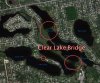
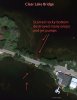
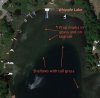
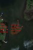
The images of Whipple Lake and Clear Lake show small inland lakes that are hazardous to jet skis, Look at the images and now you know what to look for BEFORE going to a new lake.

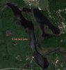
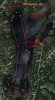
The images of Crotched Lake (Post 2) show a lake thats very deep with a very steep coast line perfect for riding jet skis.

Now I know most of you experienced guys and gals know what to look out for when you get on the water but when it comes to riding lakes you have never been on before a quick look at a satellite image can tell you where the problem areas are before you ever put your ski in.

Images are courtesy of google earth.
 

Attachments

  • Whipple Lake 1.jpg
    Whipple Lake 1.jpg
    619.6 KB · Views: 26
  • Whipple Lake 2.jpg
    Whipple Lake 2.jpg
    922.2 KB · Views: 26
  • Whipple Lake 3.jpg
    Whipple Lake 3.jpg
    506.1 KB · Views: 22
  • Whipple Lake 4.jpg
    Whipple Lake 4.jpg
    869.1 KB · Views: 23
Last edited by a moderator:
Satellite images set 2.

Typically you can tell a grassy bottom from a rocky bottom by the color. Shallows are easy to spot because deep water reveals no unusual colors.

One thing that sucks is if the satellite image was taken when the sun was reflecting off the surface of the lake your trying to look at then you will not be able to see what your looking for.
 

Attachments

  • Clear Lake and Long Lake Bridge.jpg
    Clear Lake and Long Lake Bridge.jpg
    472.4 KB · Views: 15
  • Clear Lake and Long Lake Bridge Close Up.jpg
    Clear Lake and Long Lake Bridge Close Up.jpg
    166.2 KB · Views: 16
  • Crotched Lake.jpg
    Crotched Lake.jpg
    144.7 KB · Views: 15
  • Crotched Lake Steep Coast Line.jpg
    Crotched Lake Steep Coast Line.jpg
    101.6 KB · Views: 14
Last edited by a moderator:
This is Seadoobuddys lake. If I were to go ride there without him, not knowing anything about this lake, I would know about these grassy shallows with prop marks before going there and I would avoid the areas circled in red and stay in the middle of the lake as much as possible.

All this information is mainly for the safety of your jet pump, boats don't usually have a problem going through these grassy shallows but jet pumps suck things in which is bad and sometimes VERY bad.

I gauge depth by the amount of prop marks I see in the shallows.
 

Attachments

  • Cedar Island Lake.jpg
    Cedar Island Lake.jpg
    163.1 KB · Views: 17
Last edited by a moderator:
Hi Joe,

That looks good but a little deceiving. The only bad spot for a boat is just to the right of the bottom circle at the left....just below where the boat is. That leads into a canal that can be seen from Cedar Island Road. One other shallow canal is to the left and can't be seen in your pic.

This lake is a bit shallow by the shoreline esp at the Far East & S central points. that is where boats anchor and people swim/ play volleyball.

Yes the lake can be a bit weedy at times esp in the spring before weed control is put down.
 
It is deceiving, the image's I made are meant to be used as a loose reference so you know what to look out for when looking at new lakes yourself in google earth or whatever service you choose.

Also keep in mind that there of course can be geological changes as some of the images you come across may be a year or more older than a lakes current condition. We all know that water depth and erosion varies constantly and humans make changes as well.

Can you tell I hate rebuilding my jet pumps? lol
 
Last edited by a moderator:
You guys are probably already aware of this, but if not...

http://www.michigan.gov/dnr/0,1607,7-153-30301_31431_32340---,00.html

It's been a great resource for me when going to new lakes for the first time. Like mentioned above, lakes change over time and the depth maps on the site above were done some time ago...quite some time ago...but I find it to be fairly accurate in my experience. Also, it's limited...doesn't have every single inland lake, so the satellite deal is still a good resource as well.
 
Back
Top